My daughter took my wife and I for a camping trip to three islands situated a mere stones-throw from the 'mainland' South of Oban. Beginning on Seil island and then down to a ferry to reach Luing island where we had a camp at Blackmill Bay. On the way back to the ferry on the following day we made a wee trip down to Toberonochy where we had a lesson in successful vegetable gardening from a gentleman living there in retirement and with his precious sailing boat on a mooring within sight of his home. A further trip to the West coast on Luing to reach Cullipool, another area for the quarrying of slate in the past, and the wee .94 metre trig point above the village. Well worthwhile having a bowl of soup and home made bread in the cafe come visitor centre in the village. Back to Seil and then down to Easdale, a very small island off Seil, on the West coast of the island where slate quarrying must have been on the grand scale with around thirty-forty wee slate houses, now all rendered and whitened, on the island. Along to near the Clachan bridge to then get down to our overnight camp above the Puilladobhrain Anchorage to meet some of the sailing folks, with boats moored nearby, and stretching their legs on land. We spent the following day on Kerrera island and reached the ancient Gylen castle perched on conglomerate rocks above the sea. At the wee house at Lower Gylen we enjoyed another bowl of excellent soup and bread. Ferry back to near Oban to reach the vehicle for a return home.

Seil.
 The Gateway to Seil island.

 The Small ferry that connects Seil to Luing
 Luing.
 An old decaying Mill close to Blackmill Bay.
 Mel and trailer arriving at Blackmill Bay.
 The Kelpie.
 Peaceful camping at the Bay.
 Evening at the campsite from Blackmill Bay looking out to Lunga..
 Perhaps Otter lookout spots at Blackmill Bay.
 Trig point.94 above Cullipool.
 Looking down on Cullipool on Luing with the water filled Slate quarry on our way from the .94 metre Trig Point.
 Back to Seil. The crags above Ellanabeich seen from Easdale.
 One of the many wee cottages on Easdale.
 The water filled Quarry on Easdale....Mull behind.
 Exploring Easdale.
 From Easdale across the Firth of Lorn to the hills on Mull.
 Kerrera.
 Gylen Castle on Kerrera island.
 Return from Gylen castle.
 The 'cafe' at lower Gylen.
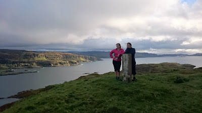 Trig point .189 on Kerrera.


The Small ferry that connects Seil to Luing

Luing.

An old decaying Mill close to Blackmill Bay.

Mel and trailer arriving at Blackmill Bay.


Evening at the campsite from Blackmill Bay looking out to Lunga..

Perhaps Otter lookout spots at Blackmill Bay.

Trig point.94 above Cullipool.

Looking down on Cullipool on Luing with the water filled Slate quarry on our way from the .94 metre Trig Point.

Back to Seil. The crags above Ellanabeich seen from Easdale.


Exploring Easdale.


Gylen Castle on Kerrera island.

Return from Gylen castle.

The 'cafe' at lower Gylen.

Trig point .189 on Kerrera.
Comments
Post a Comment