
Several of our trips to Corse began with a flight into Nice airport.
Before reaching the port for a ferry to Bastia or on one occasion to Calvi we trended towards the wee hill with the outlook over the city. On other occasions a flight into Bastia Poretta was the choice of to reach the island.
The trail takes the walker from Calenzana down to Conca following ancient paths and mule tracks used in the past to move animals to the higher areas in the summer season. This practice of transhumance carried out on many parts of the route is still practiced today. It is not unusual to find goats, pigs, sheep and cattle along the trail especially near to the several bergeries (small high level stock farms) encountered during the walk.
The trail was initiated by Michel Fabrickant a civil servant and mountaineer who worked on the Island and who took onboard the itineraires Corse of Jean Loiseau and the idea of Guy Degas of a route from Calvi to Porto Vecchio. Thus came along the organised linkages between the old tracks to create a continuous trail between the two villages.
The GR20 is now looked after by the PNRC Park Natural Regional Corse.
 |
| A look back to Calenzana when heading South. The prominent clock/bell tower was a later addition to the Eglise St. Blaise. Close to the village can be found the Chapelle di Santa Restituda that contains the Christian martyr's sarcophagus. |
The sarcophagus of Santa Restituda.
 |
| Eurolanders revving up to get down to Calinzana after getting a sniff of the salt air. |
 |
| After a strenuous day...first day out with a heavy rucksack, fairly steep mixed terrain and still getting accustomed to the heat with a bit of contouring to do before reaching a water supply and a camping pitch. |
 |
| The main part of the supply chain to Piobbu refuge. |
Our first taste of camping and of the refuge facilities on the GR20.
 |
| Leaving the first camp beside refuge d'Ortu di U Piobbu heading out to Carozzu where we would spend our second night. |
 |
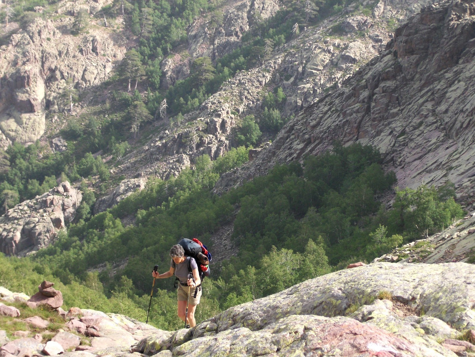
The first three days on the GR20 from the North are strenuous days out with full packs.
The welcome wee source between Mandriaccia and Bocca Piccala on stage two. |
 |
| Approach to Carozzu. |
 |
On the trail to Carozzu.
Our stony camping at Carozzu in 2008....using our new tent. |
 |
The gateway to the Spasimata slabs from Carozzu.
Spasimata slabs.
|
Heading up the Spasimata gorge after leaving Carozzu.
The Muvrella gap on stage three.
 |
Walkers resting after the steep pull up from Haut Ascu.
|
 |
| The descending to Haut Ascu that was once a small ski station but has now fallen into disrepair....well at least it was this way in June 2013. |
 |
| Strong opinions after this tree was cut down above Haut Ascu. |
 |
| The refuge, shop and camping at Haut Ascu. |
 |
A beautiful morning at Haut Ascu.
Looking back to direction of Haut Ascu with the old routes to the Cirque in view.
Down into the cirque from the col.
|
 |
Descending into the Cirque.
|
 |
In the Depths of the Cirque.

A wee ladder to begin the re-ascent.
|
 |
Having descended into the cirque a re-ascent to the Bocca Minuta had to be made. As far as I know, after the huge rock/debris fall, the chains have now been removed.
|
The old route through the Cirque. The Cirque de la Solitude stage is now closed to walkers after a very tragic rockfall during heavy rainfall in the middle of June 2015.
Stage four has now been re-routed onto the high ground on Monti Cintu before heading down to the refuge at Tighjettu.
 |
| A wee bridge gets you towards the slabby area after leaving Haut Ascu to gain Monti Cintu. I was in this area prior to the cables being set up so now it will be more secure when carrying a large heavy rucksack on the GR20. |
 |
The path into Cintu after getting through the slabs.
|
 |
| Snow still around at Lac d'Argentu and on the above slopes to reach Cintu. |
 |
| Monti Cintu summit. |
A look back to the summit area of Monti Cintu after the weather cleared.
Tighjettu refuge.
Our camp at Tighjettu.
 |
After camp at Tighjettu refuge we are heading down to Vallone for a bit of breakfast.
The Auberge U Vallone
Weather battered sign boards are often found on the route. |
 |
A bowl of lunchtime soup at Mori the highest refuge.
|
 |
Pigs on the GR20 trail. The only time that we came across one of the legendary Sanglier, the wild porks, was first of all hearing two shots when descending from the bocca Laparo while walking the MM Centre. Later we could see the outcome of this event in Cozzano when reaching the camping at a gite. The huge head of the dead animal was in the dog pound as a reward for the dogs part in the kill. Apparently the dogs are sent into the area to locate a Sanglier. A chase follows with the dogs leading the Boar towards the gun...the end of the boar is what we heard when descending.
These black ones are free ranging pigs but beware of taking off your sack near to them as they can sniff out a lunch within very quickly. |
 |
The bergeries de Radule a little North of Col di Vergio.
|
 |
Above Radule there is the coming together for a short distance of the GR20 and the Sentier. At other areas on the route there are a couple of crossings over the ridge of both the Mare a Mare Nord at col di Vergio and the Mare a Mare Centre at the Bocca di Laparo.
|
 |
| Strong winds over the years near to Col Pedru. |
 |
Grumpy pig family near bocca Pedru. The mother of the 'wee ones' went berserk soon after this image was taken when a loaded mule with mule-man and dog appeared. Big chase of the dog by the angry female. When this happens it is best just to get clear.
On the trail during stage six.
|
 |
Paglia Orba viewed from the area near Lac Ninu.
|
Lac du Ninu an area of pleasant walking between Vergio and Manganu with higher ground to walk on the following day.
The bergeries de Vaccaghja where I enjoyed a fine breakfast of bread, soft cheese and coffee.
 |
A bit of upgrading had taken place here since my previous visit six years earlier. On this occasion lunch was in progress.
|
Manganu refuge seen when approaching from the North.
Beside the trail above Manganu.
 |
| Near Bocca alle Porte in 2007. Then it was named as breche Capitellu. |
 |
An old snowfield on stage between Petra Piana and Manganu....middle of June 2013.
The other side of the col as we found the same area in 2007 when it was labelled breche du Capitellu.
The seasons can be very different.
|
 |
| Walkers descending from Bocca alle Porte heading for Manganu June 2013. |
The Bocca alle Porte, the distinct notch right of centre, between Manganu and Petra Piana.
In the older guides to the route the bocca is shown as the Breche du Capitellu and this is now correctly shown as
what I call Probably the finest passage on the route.
Obviously a way of getting down to Corte an important old town on the Island. :-)
 |
| Conditions along the trail can vary according to what has been left behind from winter. Both the images were taken in the middle of June but with a separation of six years. |
Lac du Melu in 2007.
 |
Bocca Rinosu in 2007.
|
 |
| Approaching bocca Rinosu in 2013. |
 |
| Snowfield above Petra Piana. |
 |
Petra Piana refuge while descending from bocca Muzzella. Many of the refuges for overnights during the GR20 walk have to be descended to reach and generally to start the following morning you have an uphill walk to continue the walk. There is a choice from Petra Piana...low level or high level. To reach the Tolla bergeries for supplies the path is shown going downhill and then, of course, an fairly gentle uphill walk to l'Onda. The high level route along the cretes is more direct.
Tolla bergeries. |
A selection of provisions available at Tolla bergeries. On my first visit I chose a lump of the Coppa dried wild pork that lasted as a protein source for several days. No sharing to do since Marie-Francoise is a veggie.
An alternative route between Petra Piana and l'Onda is to travel along the cretes.
 |
| Monte Ritondu from the Cretes. |
 |
| On the Cretes heading towards Petra Piana. |
 |
Petra Piana refuge seen from the Cretes.
A wee seat on the Cretes to take in the fine terrain. |
Refuge l'Onda from the Cretes.
 |
| l'Onda refuge. |
Camping at l'Onda at the bergeries below the Refuge. Campers inside the fence animals on the outside.
 |
| Lasagne at l'Onda. |
 |
Goats and sheep at l'Onda.
|
 |
| Sheep milking for making Brocciu cheese at l'Onda refuge. |
 |
Walkers having breakfast at l'Onda bergeries.
l'Onda Begeries as we found it in 2007. |
 |
Monte d'Oro from the shoulder up Muratello.
In early June 2013 the route up to Muratello from Vizzavona had some snowfields remaining.
|
 |
Down from Muratello.
|
 |
| Between Vizzavona and Muratello 2013. |
 |
| Getting close to Vizzavona after descent from Muratello 2007. |
 |
Vizzavona.
Generally accepted as the halfway stop between the northern part of the GR20 and the Southern part of the route.
The North has nine stages whereas the South has six stages. Many folks on the trail use the narrow gauge train system to take a day off in either Ajaccio or in Corte to perhaps to restock on supplies not available on the trail or to just do something different from the willingness to trudge in the beautiful terrain found on L'ile de Beaute.
The Corsican way of trying to close the bar in Vizzavona. |

|
The Dortoir/Hostel behind the Hotel I Laricci in Vizzavona.
A creaky metal army bed and a very hot shower are on offer here.
Dinner and breakfast can be purchased in the main hotel. |
 |
What is left of the Grand Hotel de la Foret in Vizzavona that was favoured by well-off folks in the early part of the 19th, century. The railway did not reach here until much later in the century. The Cascade des Anglais is just above the village so I guess that many English visitors took to the water in the inviting pools of the river.
|
Approach to Bocca Palmento with Monte d'Oro behind.
 |
| Welcome source at Bocca Palmento. |
 |
| The bergeries d'Alzeta. |
 |
| Scarpacceghje. |
 |
Bergeries Scarpacceghje ....all three of these buildings are to be found between Vizzavona and Capanelle.
Fairly remote with footpath access only. I guess, in the past, used solely in the summer season.
|
 |
The three buildings offering accommodation at Capanelle. seen from the way to Monte Renosa.
On the left is the Gite U Renosu gite/ski station, in the centre with the green roof is the PNRC Bothy and with the red roof U Fugone/Capanelle. |
 |
Breakfast at Renosa.
Lac du Bastani.
|
A day trip to Monte Renosu from Capanelle.
A busy lunchtime when we were passing through the Bocca de Verdi.
Supplies were dropped here at refuge Prati during WW2.
 |
| Prati refuge seen from Punta de Cappella ...on the green shelf at almost dead centre in the image. |
Nearing Bocca di Rapari en route to refuge d'Usciolu.
 |
The tree covered Bocca Lapari.
Cozzano below.
The very fine cruising along the high ridge between refuge Prati and Usciolu. |
 |
| Camp at Usciolu useful to have some parachord to attach the guying points to stones. |
 |
| I arrived early at Usciolu.....by staying overnight at Croci it gets you forward of those staying at Asinau. The tents in the image are those for hire by the refuge folks so those arriving with their own tents have not always the best terrain to pitch on. Well I had the choice of what was remaining and that before those homing in from both directions. |
 |
No problems with these animals beside the Trail although M looks a bit concerned.
Monte Alcudina in the distance during a long day from Usciolu to Asinau
|
 |
The signboard above the Forcinchesi stream.
When connecting to the original route after leaving Croci when coming from the South I changed direction at the Cavallara bergeries.
Plenty of choice when coming from the North for an overnight stop.
The stage Usciolu to d'Asinou is long and at the end of a tiring day and with the 600mtrs. or so to climb up to Monte Alcudina could be undesired. Taking the wee track from the 'Forcinchesi junction' to reach Cavallana Berg. and then Croce Bergeries for the night. The GR20 can be followed to the col below Alcudina, easy climb from there, then down to refuge d'Asinou.
Alternatively Croce can be reached by leaving the main trail at Bocca di l'Agnone and by doing so two other overnight stays could be had at both Begreries de Bassetta or further on at Matalza.
The bergerie/refuge at Croci in 2013 under expansion. Good food, camping and hot showers.
Start of the climb up to Monte Alcudina at the Furcinchesu bridge
The tumbled cross on Monte Alcudina in 2007.
|
 |
| The descent from Monti Alcudina and then down to refuge Asinau. |
 |
| Camp at Asinau with the beginning of the Bavella towers behind. |
 |
| The bergeries of Asinau. |
More varieties of plant-life when reaching the South.
 |
| Strangleweed found on the way to Bavella. |
In amongst the Bavella towers on the penultimate stage when coming from the North a sign beside the trail a short distance from Asinau indicates the so-called alpine varient. A kind of a waltz around the several Towers with a chain draped over a wee rock pitch to assist the heavily laden walkers.
 |
Weathered rocks near to Paliri.
The rubbish skip that we came across in 2007 at the ruins of Capeddu close to the source.
Seemed to be ignored by campers...... when passing this way in 2013 it had been removed.

As I found the area in 2013 when travelling S-N.
The Frenchman having a Nap as I was passing. I got to know him during the following 14 days.
|
|
|
| I guess that this could be applied to many of the multi day walks perhaps. |
 |
The quiet satisfaction of reaching the final Col above Conca ....the Bocca d'Usciolu.
A happy bunch of GR20 folks at lunch in Conca.....mixture of British, French and Dutch.
The camping at Conca. |
 |
The quiet road into Conca where there is a Gite/restaurant with camping facilities and is an ideal place to have a celebratory lunch. The gite, La Tonnelle, runs a mini bus down to Sainte Lucie de Porto Vecchio where there is a nearby camping site with access to the warm sea.
Time to reflect on a grand journey through the mountains of Corse along the 'jairvan'. Quite apart from the roughness of the trail and the Spartan conditions most of the time during the walk there are the meetings and conversations with folks during the walk. Good memories of the jolly gendarme a regular walker on the route, the two Belgian walkers who included Monte Cintu as a day walk travelling light from Tighettu refuge, the brother and sister from southern France, the two Dutch walkers who had walked several of the British long distance routes and many others carrying loads and camping. This is a delightful way of spending a couple of weeks walking. We enjoyed the island so much that we returned to re-visit the GR20 and five other multi day routes.
Recently plans have been announced to upgrade/rebuild many of the refuges on the route probably to the standards of those to be found in most refuges on the mainland of Europe. |

After a bus trip from PortoVecchio to Bastia we had an overnight in the wee shed in Mme. Vignon's garden with breakfast before heading for the ferry. The old town in Bastia, above image, is where an evening meal was had.
Always a joy spending time on an island and for us the Port in Bastia to get us to Nice for a flight back to our island followed by a 150 mile journey from Edinburgh to our home.
I guess easier and more relaxing when going to Corsica when retired. To fit the travel through the Corsican hills into a fortnight's holiday would be at least a bit of a scramble time-wise unless of course if you are fleet of foot and as many seem to do linking the stages into fewer days in the hills. However it is, as many do, possible to break the journey into two visits perhaps with a division at Vizzavona.


Really enjoyed this report as the GR20 is something I have always wanted to do. I always worry I might not be up to it as it is flagged as being pretty tough, and although having done some hiking in mountain areas over the years, I'm not sure how this might compare.
ReplyDeleteI guess it is tougher than the Mare a Mare Sud and the Mare a Mare Nord, both of which we have done, but is it much harder? I'd love to try one day!
Excellent and informative account. I'm thinking of doing this next year. I'm a tortoise not a hare. I can cover distance and elevation at a slow and steady pace. I live in the Lake District UK and can cover 15 miles of multiple hills in a day, but I realise that two weeks of this would be pretty wearing ! I wondered from your account is there possible places to pitch a tent between the huts. Is it just lack of water that prevents this of the terrain? Also what sleep mat did you use, as finding one that fits the compromise between weight, bulk and comfort is a bit of a challenge in itself.
ReplyDeleteThanks Anna